Rick and I took a hike last week into Table Rock State park. In the past we have tackled the Table Rock trail at the park during a severe thunderstorm. Seriously!
This hike we decided to take on the Pinnacle Mountain Trail in much better weather. Both trails are listed on the trail map as a strenuous hike. The Pinnacle trail has a bit more elevation change and is also a bit longer overall compared to the Table Rock trail. We would be hiking almost eight miles total in this hike. We have done the Table Rock trail multiple times together and don't find it overly strenuous, so we were ready to tackle this trail.
Here is a overlay of our looped hike on Google Earth:
As we approached the three mile mark on our way up, we both agreed that we liked this trail more than the Table Rock trail. The first part of this trail stays close to the Carrick creek which provides some nice background noise and some beautiful scenes. We also hiked behind and below a few small waterfalls on our way to the top.
One of the best views along the trail is on a rock outcrop known as Bald Knob. At this spot, we stood on the edge of a cliff that gave us awesome views.
It's a good thing we were able to stop and relax at that place because the toughest was yet to come. We only had about half a mile left to the top from Bald Knob, yet we had over 500 ft left to climb. The trail started to become steep and we were forced to take frequent, short breaks. At one of our breaks, I looked up the hill and saw a posted white sign. It wasn't far from us. I pointed it out to Rick and indicated that it may be the end of our climb. We pushed on and reached the sign just in time for another break. Unfortunately, the sign was not the top, in fact there was a large hill still to our right. The hill laughed at us as we realized we would have to climb it. The sign was a marker for the beginning of the Foothills Trail. It also had a trail map of the Table Rock park area. Again, it listed both trails as "strenuous".
"Wait a second!", I said. "If Table Rock is strenuous, then this should be listed as ridiculous! "It's not even a fair comparison to put them on the same level. The scale is broken!"
Rick was getting a drink of water while I ranted about the difficulty. I pointed to the top of the hill and reminded my partner that we still had to climb it. He asked me to stop trying to motivate him.
The last one or two tenths of a mile felt like a climb that would never end. It was so steep that when I would stop to catch my breath, I held onto the trees to keep from falling back down the hill. Both of us struggled for a bit, but it made it that much more satisfying when we reached the summit. On the very tippy top of the mountain stood a tree in the middle of a small clearing. No, there was no man handing out balloons for our success. Not even a sign that congratulated us. There was only the tree.
Instead of following the same trail down, we used the Ridge trail that headed East toward Table Rock. This trail was much easier, but we were also going down, so it may have been deceiving. As we worked our way down we kept looking for a clearing to have our lunch. The Ridge trail doesn't offer very many views into the mountains, because it takes you through such dense forest. We finally got tired enough that we found a fallen tree to use as a bench and gave up on finding a view. At lunch Rick said that the climb to the top was about as much as he could take. I agreed that it was the steepest hike I can remember taking and then I started to complain about the trail being described as "strenuous" instead of "ridiculous" again.
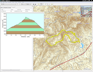
Below is a the elevation map that my Garmin captured while we hiked. You can see the sharp incline on the left of the peak that we traveled and that almost killed my friend.


No comments:
Post a Comment